
On this page
How to: Process KML Files with Python's Shapely Library For Detecting Geo-boundaries

Introduction to KML Files
KML (Keyhole Markup Language) is an XML-based file format used for displaying geographic data in applications like Google Earth, Google Maps, and other GIS (Geographic Information System) applications. KML files contain geographic features such as points, lines, and polygons with associated metadata.
Common Use Cases for KML Processing
- Urban Planning: Analyzing ward boundaries, administrative regions, and city zones
- Environmental Monitoring: Tracking pollution sources, protected areas, and wildlife habitats
- Logistics and Transportation: Route planning, delivery zones, and service areas
- Real Estate: Property boundaries, neighborhood analysis, and market research
- Emergency Services: Response zones, evacuation routes, and critical infrastructure mapping
Why Use Shapely for KML Processing?
Shapely is a Python library for geometric operations that provides:
- Efficient geometric computations
- Support for various geometric objects (points, lines, polygons)
- Spatial analysis capabilities
- Integration with other geospatial libraries
- Clean, Pythonic API for complex geometric operations
Setting Up Shapely Library
Installation
# Install Shapely and required dependencies
pip install shapely numpy

# For additional geospatial capabilities
pip install geopandas folium matplotlib
Basic Imports
from shapely.geometry import Point, Polygon, LineString
from shapely.ops import transform
from shapely import wkt
import xml.etree.ElementTree as ET
import json
Reading and Parsing KML Files
Understanding KML Structure
KML files are XML documents with a specific structure. The main elements include:
<Document>: Root container<Placemark>: Individual geographic features<Polygon>: Area features<LineString>: Linear features<Point>: Point features<coordinates>: Coordinate data
Basic KML Parser
def parse_kml_file(file_path):
    """
    Parse a KML file and extract geometric features
    """
    tree = ET.parse(file_path)
    root = tree.getroot()

    # Define namespace (KML uses specific namespaces)
    ns = {'kml': 'http://www.opengis.net/kml/2.2'}

    features = []

    # Find all Placemark elements
    for placemark in root.findall('.//kml:Placemark', ns):
        name = placemark.find('kml:name', ns)
        name_text = name.text if name is not None else "Unnamed"

        # Check for different geometry types
        polygon = placemark.find('.//kml:Polygon', ns)
        if polygon is not None:
            coords = extract_polygon_coordinates(polygon, ns)
            if coords:
                features.append({
                    'name': name_text,
                    'type': 'Polygon',
                    'geometry': Polygon(coords)
                })

        point = placemark.find('.//kml:Point', ns)
        if point is not None:
            coords = extract_point_coordinates(point, ns)
            if coords:
                features.append({
                    'name': name_text,
                    'type': 'Point',
                    'geometry': Point(coords)
                })

    return features

def extract_polygon_coordinates(polygon_element, ns):
    """
    Extract coordinates from a KML Polygon element
    """
    outer_boundary = polygon_element.find('.//kml:outerBoundaryIs', ns)
    if outer_boundary is None:
        return None

    coordinates = outer_boundary.find('.//kml:coordinates', ns)
    if coordinates is None:
        return None

    # Parse coordinate string
    coord_text = coordinates.text.strip()
    coord_pairs = coord_text.split()

    coords = []
    for pair in coord_pairs:
        if pair.strip():
            lon, lat, alt = pair.split(',')
            coords.append((float(lon), float(lat)))

    return coords

def extract_point_coordinates(point_element, ns):
    """
    Extract coordinates from a KML Point element
    """
    coordinates = point_element.find('kml:coordinates', ns)
    if coordinates is None:
        return None

    coord_text = coordinates.text.strip()
    lon, lat, alt = coord_text.split(',')
    return (float(lon), float(lat))
Example Usage
# Parse a KML file
features = parse_kml_file('wards.kml')

# Print information about each feature
for feature in features:
    print(f"Name: {feature['name']}")
    print(f"Type: {feature['type']}")
    print(f"Area: {feature['geometry'].area}")
    print("---")
Geometric Operations and Transformations
Basic Geometric Operations
def analyze_geometry(geometry):
    """
    Perform basic geometric analysis
    """
    analysis = {
        'area': geometry.area,
        'length': geometry.length if hasattr(geometry, 'length') else 0,
        'bounds': geometry.bounds,
        'centroid': geometry.centroid,
        'is_valid': geometry.is_valid
    }
    return analysis

def transform_coordinates(geometry, from_crs='EPSG:4326', to_crs='EPSG:3857'):
    """
    Transform coordinates between different coordinate reference systems
    """
    from pyproj import Transformer

    transformer = Transformer.from_crs(from_crs, to_crs, always_xy=True)
    return transform(transformer.transform, geometry)
Spatial Relationships
def check_spatial_relationships(geometry1, geometry2):
    """
    Check various spatial relationships between two geometries
    """
    relationships = {
        'intersects': geometry1.intersects(geometry2),
        'contains': geometry1.contains(geometry2),
        'within': geometry1.within(geometry2),
        'touches': geometry1.touches(geometry2),
        'crosses': geometry1.crosses(geometry2),
        'overlaps': geometry1.overlaps(geometry2),
        'disjoint': geometry1.disjoint(geometry2)
    }
    return relationships

def find_intersections(geometries):
    """
    Find all intersections between a list of geometries
    """
    intersections = []
    for i, geom1 in enumerate(geometries):
        for j, geom2 in enumerate(geometries[i+1:], i+1):
            if geom1.intersects(geom2):
                intersection = geom1.intersection(geom2)
                intersections.append({
                    'geom1_index': i,
                    'geom2_index': j,
                    'intersection': intersection
                })
    return intersections
Practical Scenarios: Ward Detection
KML Processing Workflow
The following diagram illustrates the complete workflow for processing KML files with Shapely:
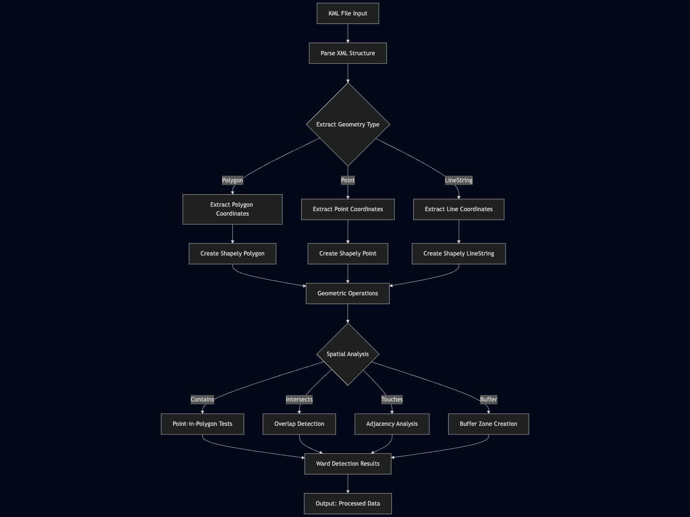
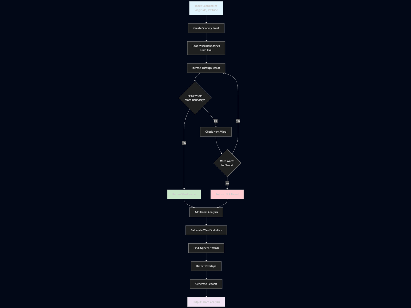
Ward Detection Process
The ward detection process follows this specific workflow:
Ward Boundary Analysis
class WardProcessor:
    def __init__(self, kml_file_path):
        self.features = parse_kml_file(kml_file_path)
        self.wards = [f for f in self.features if f['type'] == 'Polygon']

    def find_ward_by_coordinates(self, longitude, latitude):
        """
        Find which ward contains the given coordinates
        """
        point = Point(longitude, latitude)

        for ward in self.wards:
            if ward['geometry'].contains(point):
                return ward['name']

        return None

    def get_ward_statistics(self):
        """
        Calculate statistics for all wards
        """
        stats = []
        for ward in self.wards:
            analysis = analyze_geometry(ward['geometry'])
            stats.append({
                'name': ward['name'],
                'area': analysis['area'],
                'centroid': analysis['centroid'],
                'bounds': analysis['bounds']
            })
        return stats

    def find_adjacent_wards(self, ward_name):
        """
        Find wards that are adjacent to the specified ward
        """
        target_ward = next((w for w in self.wards if w['name'] == ward_name), None)
        if not target_ward:
            return []

        adjacent = []
        for ward in self.wards:
            if ward['name'] != ward_name:
                if target_ward['geometry'].touches(ward['geometry']):
                    adjacent.append(ward['name'])

        return adjacent

    def calculate_ward_overlaps(self):
        """
        Calculate overlapping areas between wards
        """
        overlaps = []
        for i, ward1 in enumerate(self.wards):
            for ward2 in self.wards[i+1:]:
                if ward1['geometry'].intersects(ward2['geometry']):
                    intersection = ward1['geometry'].intersection(ward2['geometry'])
                    overlaps.append({
                        'ward1': ward1['name'],
                        'ward2': ward2['name'],
                        'overlap_area': intersection.area
                    })
        return overlaps

# Usage example
processor = WardProcessor('city_wards.kml')

# Find which ward contains a specific point
ward = processor.find_ward_by_coordinates(-74.0059, 40.7128)
print(f"Point is in ward: {ward}")

# Get statistics for all wards
stats = processor.get_ward_statistics()
for stat in stats:
    print(f"Ward {stat['name']}: Area = {stat['area']:.6f}")

# Find adjacent wards
adjacent = processor.find_adjacent_wards("Downtown")
print(f"Wards adjacent to Downtown: {adjacent}")
Advanced Ward Analysis
def analyze_ward_density(ward_processor, population_data):
    """
    Analyze population density by ward
    """
    density_analysis = []

    for ward in ward_processor.wards:
        ward_name = ward['name']
        population = population_data.get(ward_name, 0)
        area = ward['geometry'].area

        # Convert area to square kilometers (approximate)
        area_km2 = area * 111000 * 111000  # Rough conversion

        density = population / area_km2 if area_km2 > 0 else 0

        density_analysis.append({
            'ward': ward_name,
            'population': population,
            'area_km2': area_km2,
            'density': density
        })

    return sorted(density_analysis, key=lambda x: x['density'], reverse=True)

def create_ward_buffer_zones(ward_processor, buffer_distance=1000):
    """
    Create buffer zones around ward boundaries
    """
    buffered_wards = []

    for ward in ward_processor.wards:
        # Create buffer (distance in meters, converted to degrees approximately)
        buffer_degrees = buffer_distance / 111000
        buffered_geometry = ward['geometry'].buffer(buffer_degrees)

        buffered_wards.append({
            'name': f"{ward['name']}_buffer",
            'geometry': buffered_geometry,
            'original_ward': ward['name']
        })

    return buffered_wards
Best Practices and Common Pitfalls
Best Practices
- Coordinate System Awareness
# Always be aware of coordinate systems
# KML typically uses WGS84 (EPSG:4326)
# For area calculations, consider projecting to a local CRS- Error Handling
def safe_geometry_operation(geometry, operation, *args):
    try:
        if not geometry.is_valid:
            geometry = geometry.buffer(0)  # Fix invalid geometries
        return operation(geometry, *args)
    except Exception as e:
        print(f"Error in geometry operation: {e}")
return None- Memory Management
# For large KML files, process features in batches
def process_large_kml(file_path, batch_size=1000):
    # Implementation for batch processing
pass- Validation
def validate_kml_structure(kml_file):
    """
    Validate KML file structure before processing
    """
    try:
        tree = ET.parse(kml_file)
        root = tree.getroot()
        # Check for required elements
        return True
    except ET.ParseError:
        return False
Common Pitfalls
- Coordinate Order Confusion
- KML uses longitude, latitude order
- Some libraries expect latitude, longitude
- Always verify coordinate order in your data
- Invalid Geometries
- Self-intersecting polygons
- Duplicate coordinates
- Use geometry.buffer(0) to fix many issues
- Memory Issues with Large Files
- Process features incrementally
- Use generators for large datasets
- Consider using spatial databases for very large datasets
- Precision Issues
- Floating-point precision can cause problems
- Use appropriate tolerance values for comparisons
- Consider rounding coordinates when appropriate
Conclusion
Processing KML files with Python's Shapely library provides a powerful way to work with geographic data. This guide covered the essential aspects of:
- Reading and parsing KML files
- Performing geometric operations
- Implementing practical solutions like ward detection
- Following best practices and avoiding common pitfalls
The combination of KML's widespread use in GIS applications and Shapely's robust geometric capabilities makes this approach ideal for many geospatial analysis tasks. Whether you're working on urban planning, environmental monitoring, or any other geographic data processing task, these techniques will help you build reliable and efficient solutions.
Remember to always validate your data, handle errors gracefully, and consider the coordinate reference systems you're working with. With these tools and practices, you'll be well-equipped to tackle complex geospatial challenges.